Saturday, December 10, 2016

12/09/16 - BAER Burned Area Severity Maps Now Available

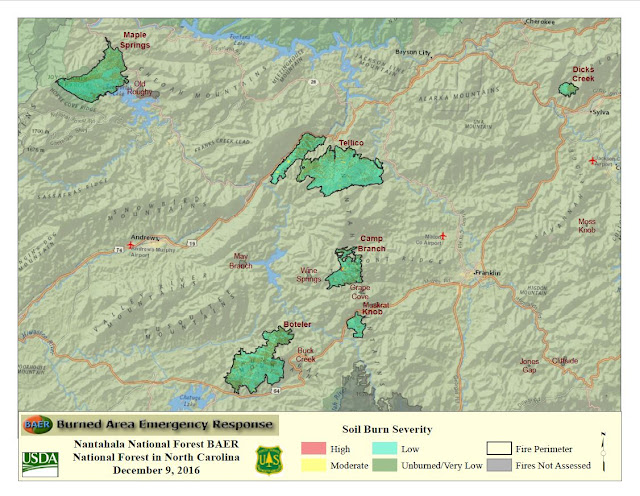
The Burned Area Emergency Response, BAER, team has released their Burned Area Severity maps .  Below you will see detailed maps showing the burned areas within the fire perimeters and how severe the burned areas are.

Each map shows the burned areas, the severity of the burn, and in most maps, the very low and unburned areas within the fire perimeter.   Combined across the complex of the six fires the BAER team is analyzing, less than 1% of the burn was extreme.  By contrast, 38% of the area within the fires was very low or unburned.

This first map is an overview of the six fires the BAER team are developing a report for.  The fires they are analyzing are:

  • Maple Springs Fire
  • Dick's Creek Fire
  • Tellico Fire
  • Camp Branch Fire
  • Knob Fire
  • Boteler Fire

Each fire has a Burned Area Severity map.  NOTE:  Each map has the total burned severity of all the fires in the complex as it's legend.  Each map does not have it's own individual analysis.

Overiew Map - this shows all of the fires in complex being analyzed.


For a downloadable, printable version of the overview map, click here.


Here is the burn severity map for the Maple Springs Fire - 


For a downloadable, printable version of this map, click here.


Here is the burn severity map for the Dick's Creek Fire - 


For a downloadable, printable version of this fire, click here.


Here is the burn severity map for the Tellico Fire - 


For a downloadable, printable version of this fire, click here.


Here is the burn severity map for the Camp Branch Fire.


For a downloadable, printable version of this map, click here.


Here is the burn severity map for the Knob Fire - 

For a downloadable, printable version of this map, click here.


Here is the burn severity map for the Boteler Fire - 


For a downloadable, printable version of this map, click here.
Thursday, December 8, 2016

12/08/16 - Burned Area Emergency Response Team Update - 9:00am

The Burned Area Emergency Response Team, BAER, have started their evaluation of the wildfire areas in Western North Carolina.  Through visiting fires on the ground and doing aerial surveys, they will determine which areas need the most immediate treatment to prevent further threat to life, property and resources.

The BAER Team has an objective they use to determine their scope of work - To identify imminent post-wildfire threats to human life and safety, property, and critical natural or cultural resources on National Forest System lands and take immediate actions, as appropriate, to manage unacceptable risks.

The critical values the BAER Team uses are:  Human life and safety, property, Natural Resources and Cultural and Heritage Resources.

How BAER Works
The BAER team determines which fires they will respond to using various priorities and values above.  The first criteria is the fire is over 500 acres.  Smaller fires may qualify if there is a large risk to life, property and/or resources.

For Western North Carolina the following fires the BAER team will be developing plans for are:


  • Dick's Creek Fire
  • Boteler Fire
  • Camp Branch Fire
  • Maple Springs Fire
  • Tellico Fire
  • Knob Fire
  • Rock Mountain Fire (Georgia BAER Team)

For these fires the BAER team will submit a request to do treatments, as well as where treatment is not needed or recommended.

Those recommendations are based on the Critical Values of the BAER team and the BAER Risk Assessment Matrix, using the magnitude of the consequences of not treating against the probability of damage or loss.

The Critical Values that the BAER Team assess are:

Human Life and Safety - on National Forest System (NFS) lands only
Property - Buildings, water systems utility systems, road and trail prisms, dams, wells and other significant investments on NFS's land
Natural Resources - Water used for municipal, domestic, hydropower, or agricultural - Soil productivity - Critical habitat or suitable occupied habitat for federally listed threatened or endangered species - Native or naturalized communities on NFS lands - all on NFS lands
Cultural and Heritage Resources - Cultural resources which are listed on or potentially eligible for the National Register of Historic Places, Traditional Cultural Properties, or Indian Sacred Sites on NFS lands.

Once determining that a site is within the Critical Values, the BAER team then determines the risk associated with that site.  To help determine the amount of risk, the BAER team uses a Risk Assessment Matrix to give it a value.

The BAER Risk Assessment Matrix looks at damage and determines the magnitude of consequences on a scale of major, moderate or minor.  That is then taken into consideration against the Probability of Damage or Loss.  The two combined formulate the risk associated with each item identified.


Probability of Damage or Loss:  The following descriptions provide a framework to estimate the relative probability that damage or loss would occur within 1 to 3 years (depending on the resource):

  • Very likely.  Nearly certain occurrence (90% - 100%))
  • Likely.  Likely occurrence (50% - 89%)
  • Possible.  Possible occurrence (10% - 49%)
  • Unlikely.  Unlikely occurrence (0% - 9%)

Magnitude of Consequences:

  • Major.  Loss of life or injury to humans; substantial property damage; irreversible damage to critical natural or cultural resources.
  • Moderate.  Injury or illness to humans; moderate property damage; damage to critical natural or cultural resources resulting in considerable or long term effects.
  • Minor.  Property damage is limited in economic value and/or to few investments; damage to critical natural or cultural resources resulting in minimal, recoverable or localized effects.


When potential hazards to life or safety on NFS lands are identified, notification of hazardous or unsafe conditions should accompany any other contemplated actions.  For potential flooding or other threats that may continue downstream of NFS lands, coordinate and cooperate with the appropriate response agencies.

Once these threats are identified and rated, Emergency Response Actions are recommended for the identified areas.  When scheduling emergency response actions, those that protect life and safety should have highest priority.


Part of the strategy of these actions can be for the natural recovery of area.  Administrative closures can be used to protect life and safety to prevent additional risk.  Or other effective measures should be applied to manage unacceptable risks.

Response Action Considerations are done with the consultation with other agencies to ensure emergency response actions are appropriate, wilderness response occurs where appropriate, and in prevention of invasive species.

For full details of what the BAER team does, and how it determines responses, you can get a downloadable and printable version of their manual here.


Monday, December 5, 2016

Welcome to the BAER Page for Western North Carolina

The National Forests in North Carolina assembled a Burned Area Emergency Response (BAER) assessment team the end of November 2016, to analyze post-fire condition of burned watersheds and to plan emergency stabilization treatments for the following the western North Carolina wildfires:

- Pinnacle Mountain Fire
- Clear Creek Fire
- Piney Mountain Fire
- Cathy Gap Fire
- Party Rock Fire
- Chestnut Knob Fire
- Dobson Creek Fire
- Rock Mountain Fire
- Horton Fire
- Hwy 151 Fire
- Martin Trace Fire
- Boteler and Nantahala Branch Fires Complexes, which include -

  • Camp Branch Fire 
  • Maple Springs Fire 
  • Tellico Fire 
  • Old Roughy Fires 
  • Buck Creek Fire 
  • Falls Fire 
  • Grape Cove Fire 
  • Moses Creek Fire 
  • Jones Gap Fire 
  • Jarrett Knob Fire 
  • Wine Spring Fire 
  • Mulberry Fire 
  • Moss Knob Fire 
  • May Branch Fire 
  • Boardtree Fire 
  • Charley Creek Fire 
  • Nick Fire 
  • Ridge Gap Fire 
  • Ferebee Fire 
  • Cliffside Fire 
  • Whitewater Fire 
  • Howard Gap 
  • Knob Fire 
  • Muskrat Fire 
  • Bullpen Fire 
  • Jones Creek Fire 
  • Cathey Gap Fire 
  • Dick’s Creek Fire 

The BAER team is compiling reports that will identify immediate and emergency actions to address post-fire risks to people, property, and cultural and natural resources. Wildfire can increase the risk of flooding, erosion, and sedimentation in streams. Other potential hazards include debris flow, reduced water quality, invasive plants, or falling trees and rocks. The BAER team report will contain an assessment of watershed pre- and post-fire response, areas of concern, values-at-risk, and recommended short-term emergency stabilization treatments.

BAER emergency treatment objectives may allow for a more efficient passage of water to increase protection from accelerated erosion for infrastructure and watersheds, as well as from the spread of noxious weeds within the burned areas. Controlled access may be established in areas where it is not safe for the public to enter, or in areas that require recovery of natural resources without additional detrimental impacts. Hazard tree and rock slide removal along trails and roads may occur, along with installation of safety and informational signage in hazardous areas.

Storm-proofing for roads and trails may include removing outside berms, installing critical dips, cleaning debris from culverts, and placement of riprap along drainage routes.